Madeira
January 2023
\\ January 12 | Day 0: Arrival on Madeira
I arrived on the island in the morning from a direct 4 hour flight from Amsterdam. Although it felt like I flew to a different continent, the reality of still being in Europe were obvious when I stood outside of the airport just 15 minutes later without even having to pass through customs. The weather was sunny and the temperatures a pleasant 18 degrees. Much better than the gray skies and rain I'd seen a little too much back home.
The route I had planned was partially based on the famous MIUT ultra marathon route across the island. This route starts in the far west and traverses the 50 kilometer island in a 120 kilometer route. This route was a great starting point, but it was made to be fast and have a lot of resupplies (towns) along the route. I didn't need the those aspects, so I modified the route in a longer version that included even more highlights on the island. My route still started in Porto Moniz, so at airport I sorted out my stuff, packed my pack and took a taxi the hotel in Machico I'd booked for the last night on the island in 11 days where I dropped off my duffel bag. With a bus I headed down to Funchal, the capital in the south, to get a gas canister. By noon I was ready to get to my starting point in the north west.
The infrastructure on Madeira is astonishing. The small island has over 100 car tunnels, good roads, and an extensive bus network that can basically get you anywhere. However, the bus route to Porto Moniz isn't so efficient, and since it would take over 3.5 hours to get there by bus, I hopped in a taxi for the hour-long ride.
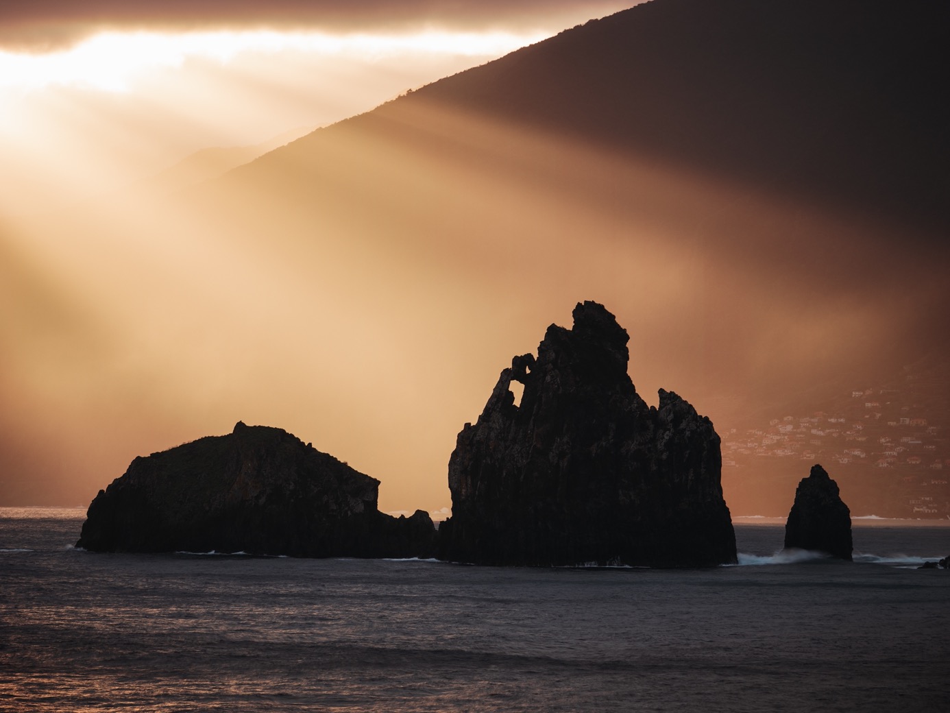
The taxi driver, like all taxi drivers on the island, was a local, and with the business being very quiet today, he was more than keen to drive me there. We set a fixed price (lower than the meter) and set off. The hour ride turned out to be an hour-long tour across the island with more facts than I could take in. I learned about the different climates of the north and south, the banana trees, saw the house where Cristiano Ronaldo grew up, and got suggestions for the best viewpoints on the island. As we drove across the island on the expressway, passing through the many tunnels, I noticed how the weather constantly changed from valley to valley: it was blue skies at first, five minutes later completely overcast, then sunny again, etc. These mountains create some extreme microclimates that I would come to hate and love in the coming 10 days. After a last tour stop in Seixal, I arrived in Porto Moniz.
This small town on the wind-beaten side of the island is very quiet and probably the favorite town I got to experience on the island. It has great views along the rugged coast to the east, the mountains that rise up steeply to the south, and the giant waves that hit the island from the north. I settled in my hotel, which turned out to be a pretty nifty one with a sauna and pools, and got ready for the hike.
\\ January 13 | Day 1: Porto Moniz to the enchanted forest
Porto Moniz via the old road to Ribiera de Janela, PR15 and PR14 to the Fanal forest
22.9km | 14.2mi
1500m | 5000ft 400m | 1400ft
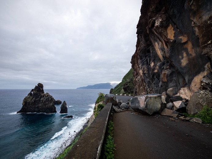
I set out just past 8:30 am. Sunrise this time of year is just past 8 am, and sunset is at 6:30 pm. Upon suggestion from the taxi driver, I followed the old road along the coast east for a bit. Nowadays, the main road runs through a couple of tunnels, but the old road follows the cliffs that are clearly trying to reclaim their territory. Most sections are not accessible anymore by car, with giant boulders blocking the road, but they are still open for foot traffic.
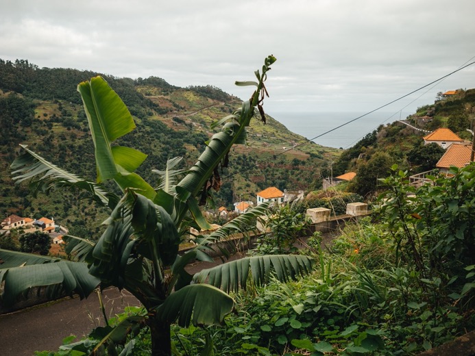
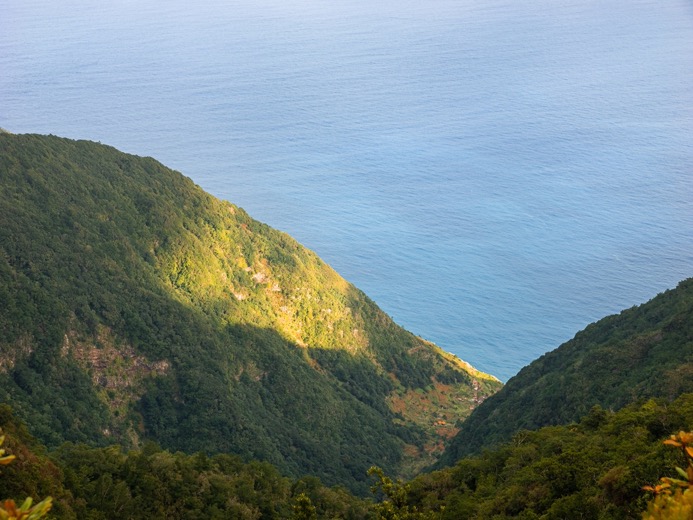
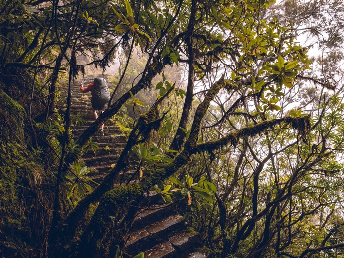
At the small village of Ribeira de Janela, I started ascending the gorge south into the forest-covered mountains. The north side of the island is wetter, colder, and a lot greener than the south side, where the bananas grow. The trail winds through the spread-out village through narrow streets, small concrete paths, and stairs. After a few hundred meters of climbing, I got to the first actual trail of the day: PR15, one of the main PR trails on the island. The concrete easy-going trails instantly gave way to the wet, muddy trails with a couple of serious tree falls I had to crawl through right at the beginning. The forest was dense and like 99% of the island, steeply sloped everywhere.
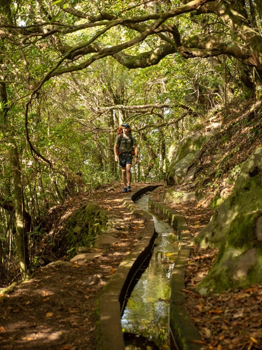
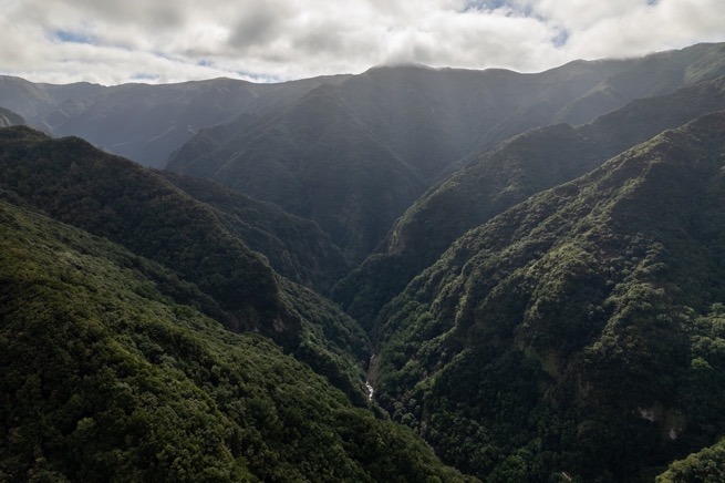
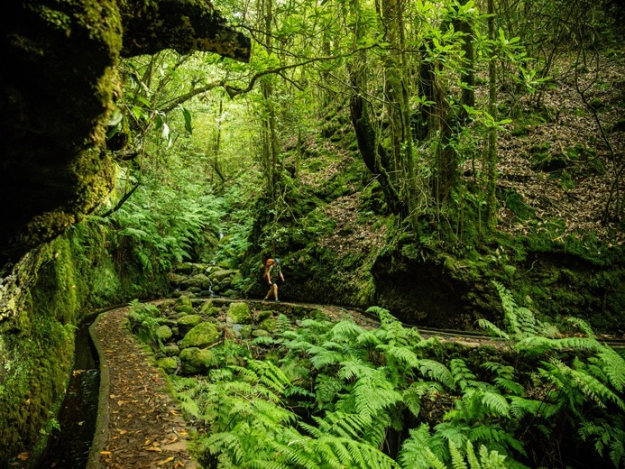
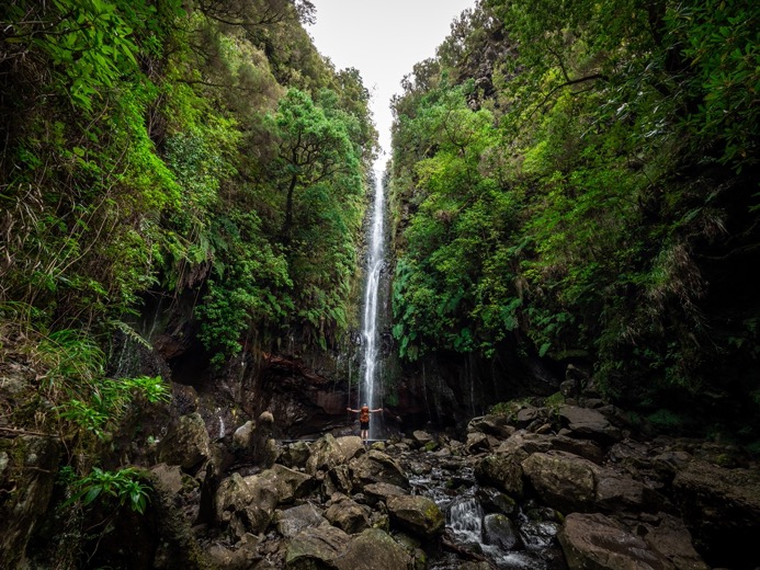
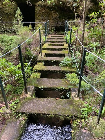
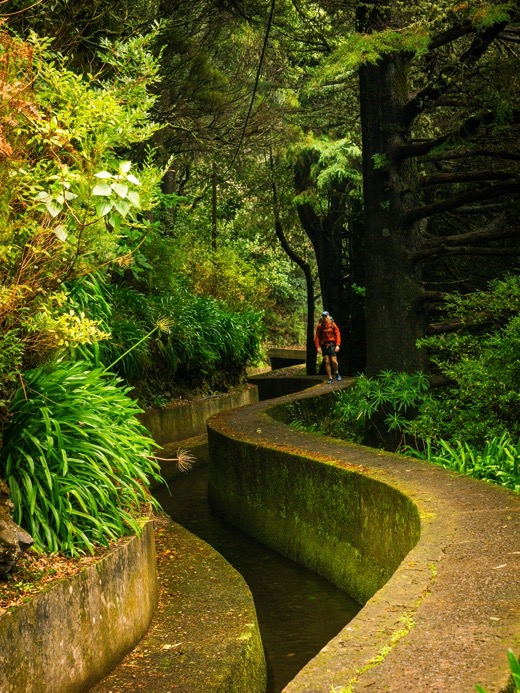
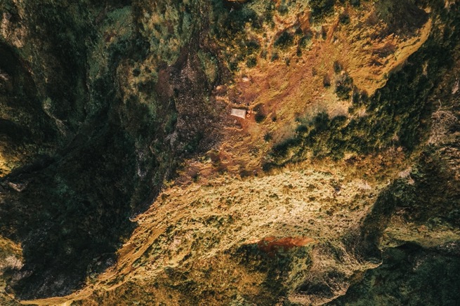
After climbing a solid 800 meters, I got to the first levada trail in no time. The levadas are small canals that are characteristic of the island. The island is only about 50 by 20 kilometers but has almost 3000 km of these canals that carry freshwater from the (northern side of the) mountains to the coastal cities for drinking water and electricity generation. Many of these canals have been turned into trails, making them sort of the highway across the island. And that's exactly how it felt with the progress I was making. The trail, though, was densely forested. Beautiful, but with little distant views into the deep valley below. I arrived at the end of the levada, where a natural creek and waterfall form the start of it. I scrambled a couple of wet, mossy rocks to get closer to the waterfall, standing 20 meters tall. Amazing sight.
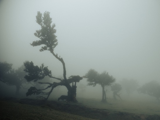
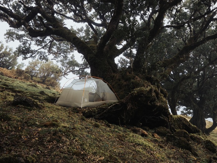
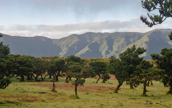
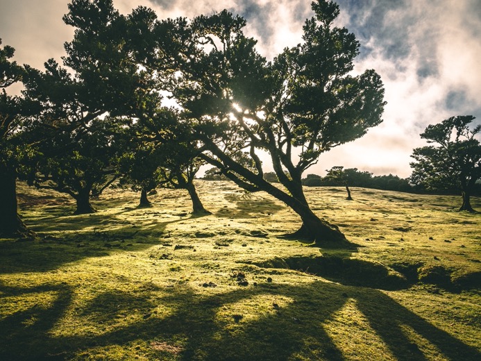
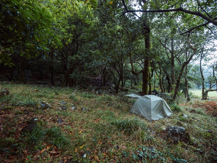
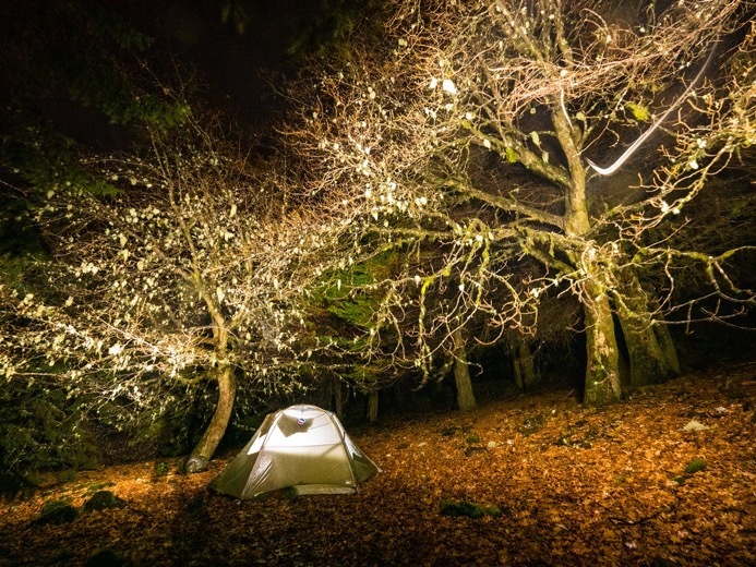
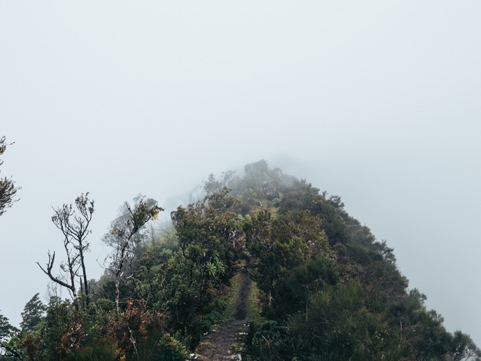
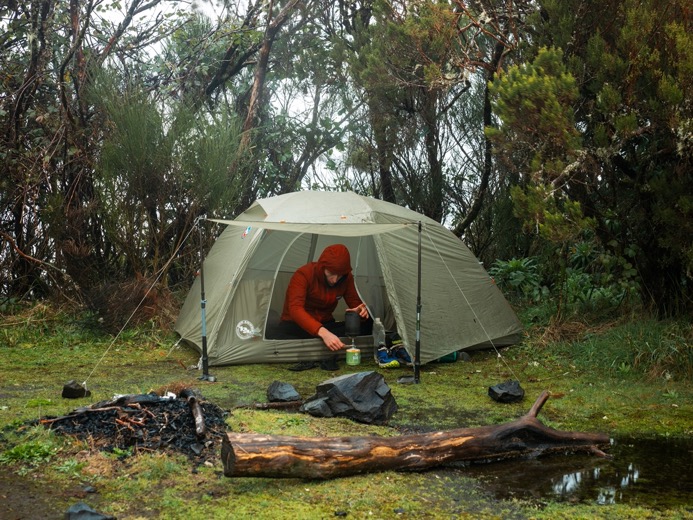
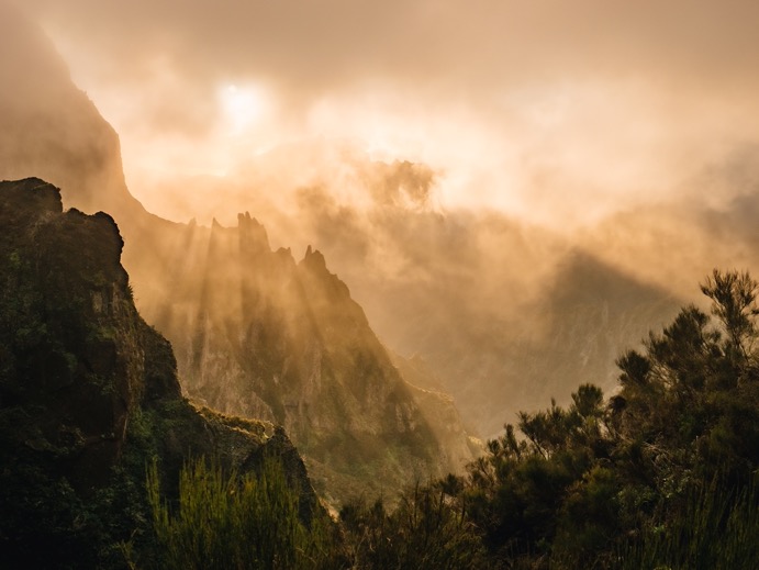
From there, I ascended some 250 meters to the top of the plateau (great plateau of Paul da Serra). This plateau in the west of the island (clearly visible on maps) has a totally different vegetation. Whereas the slopes are covered in this dense forest, up on top it's way more open. And where the skies were just blue, now I found myself in the fog. This place is home to the Fanal forest, where I planned on spending the night. The forest consists of these massive old trees scattered on hilly grassy hills. The trees are wet, and some of them partially fallen over and rotten away. In combination with the fog that blankets these trees almost daily, it just looks magical. I think I spent a good hour just walking around.
I pitched my tent on the far end of the forest in the arms of an old tree, on and surrounded by its roots. If that tree could only talk, I wouldn't have had much sleep. As I enjoyed my dehydrated (chicken masala) meal on one of its branches, the sun went down, and I slowly prepared for the night.
\\ January 14 | Day 2: The tunnel
Fanal forest to the Seixal valley via PR13, 25 Fontes valley and the tunnel Levada do Seixal
29.2km | 18.2mi
900m | 3100ft 1500m | 5000ft
The morning was clear and no longer foggy. Although it wasn't too bad last night, since even without my rainfly, my quilt felt mostly dry.
My route started with a passage through the forest once more, which again took me forever because I stopped all the time to take pictures and videos because it looked so different now without the fog. As I walked on the edge of the plateau to the east, I could see the dark blue ocean right down the steep slopes.
The trail I hiked on was easy going on the plateau. Even though I was no longer hiking between densely packed trees from yesterday, I still didn't have the far views I hoped for because now I was walking in the brush area with bushes just taller than me. But soon enough, I neared the edge of the plateau, and the vegetation was breaking up, giving me some views into the forest-covered valley below. The weather was great, sunshine, and blue skies. I had checked the weather forecast this morning, and it showed full cloud coverage all day. I started to realize that these forecasts here probably wouldn't make much sense on this island with these mountains shooting right out of the ocean, perfect for microclimates all around the island.
From the large plateau, I descended into the valley of the 25 waterfalls. The descent was steep, and sunny warm weather quickly made way for humid and shaded forests. This area is quite popular because it's so easily accessible by car from the other side. Nevertheless, it's totally worth a visit. There are literally waterfalls everywhere, with the biggest one being Risco, which is a hundred meters tall.
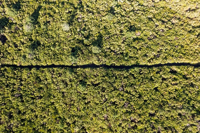
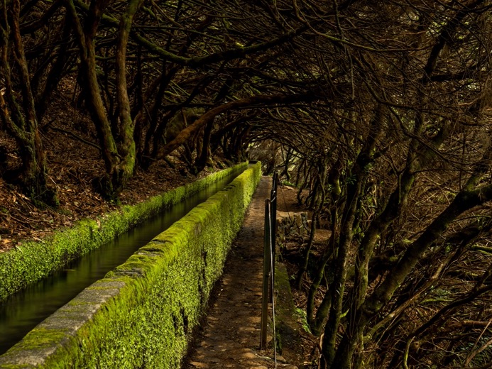
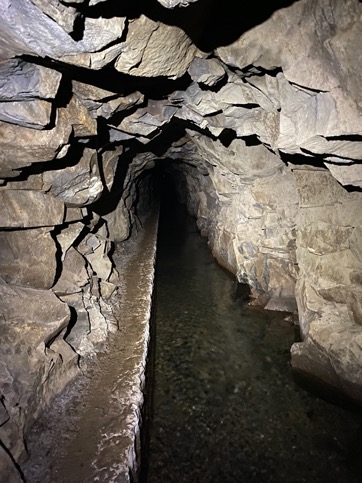
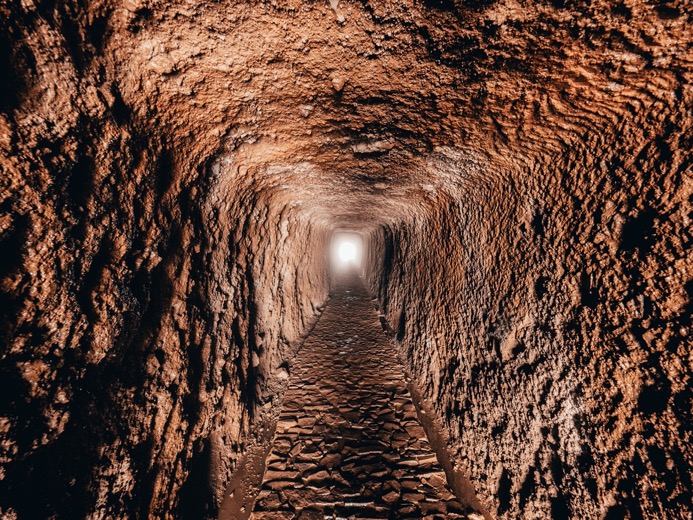
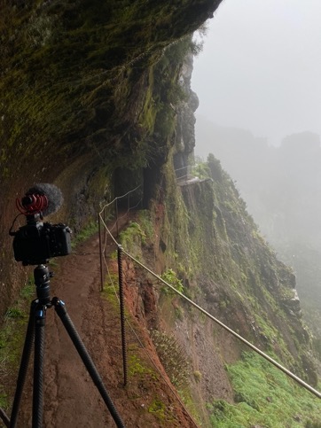
My plan for the day was to reach the valley of Seixal in the north, where I'd spotted an area suitable for camping with Streetview. But the matter was, I was about 400 meters down on the wrong side of the mountain. The normal trail up and over the mountain would have been at least 10k with 700m elevation gain. But on maps, I had spotted a tunnel going straight through the mountain. With zero elevation gain and just over 2 kilometers long, this tunnel connects a levada on the north with the south. So, following a wide levada, I came near the tunnel entrance. These levadas are a beautiful feat of engineering with aqueducts crossing ravines with a bridge on top of that aqueduct. The levadas change size based on the needed throughput, have overflows into other levadas or valleys, and are carved out of the mountainsides while losing very little elevation along their full run. And then realizing that the first of these levadas was built in the 16th century.
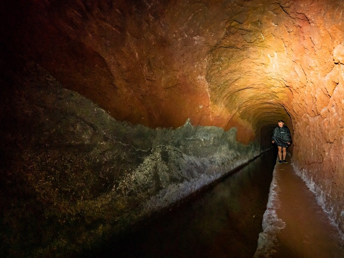
There I stood at the tunnel entrance, excited to explore. Staring into the dark, I could vaguely see a small light spot at the end of the tunnel. The levada running through it is about a meter wide and a meter deep. The path on the side is not more than 30 centimeters and, depending on the type of rock, pretty low. I could say that most of the time, I had to walk bent over with my backpack's shoulder straps loosened to lower its height.
I put on my headlamp, and into the darkness, I went. The first thing I noticed was how quickly it became completely silent. The water of the levada was a smooth laminar flow that didn't make any sound, while the sound from outside was quickly faded out by rough tunnel walls. Walking bent forward, my pack constantly scraped against the ceiling/wall as I tried not to fall into the water while leaning around rocks sticking out. This was fun, but the crossing was going to take a while.
The type of rock changed from dark black with sharp edges sticking out to all types of surfaces along the way. I passed smooth red sandstone rocks that were beautifully carved into a symmetric, grayish type of hard rock, as well as combinations of the two creating beautiful lines on the wall where they met. Some parts of the tunnel were made out of masonry stones, indicating some weak spots in 400 meters of mountains above my head.
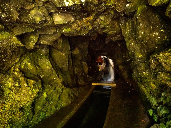
About 30% in, I heard noise in the distance: the sound of water. As I approached anxiously, I entered a larger chamber with a waterfall seeping through the rocks and fully engulfing the small path. On the narrow trail, I took off my pack and, while sitting, pulled my rain poncho over my head and then, still on my knees, put my pack on my back again. With the important parts protected against the water, I jumped through the waterfall, soaking my feet in the process. Well, actually three times, because the film ...
Ever so slowly but enjoying the uniqueness of this trail, I slowly approached the end of the tunnel, passing through several more rainy sections along the way. 75 minutes later, I stepped outside again, this time on the north side of the mountain. I took off my pack and stretched my back for a good while.
It was just before sunset and with only 30 minutes of day- and twilight left, I quickly continued my way down into the valley towards the ocean. The part that followed was a lot longer and way more exciting than I'd planned for. The trail wasn't the easy-going paths I had been on so far, but a narrow overgrown trail along the mountainside winding through dense forest. Although my multi-band GPS watch had pretty good reception through the dense forest, the trail on the map wasn't even close to what it was in reality. The trail winds through all the side valleys with most of the time vertical drops on the side. With the sun now down, I couldn't see the bottom when shining my headlight down from the trail. I passed several small creeks and a section where the trail was literally just some small logs tied together with iron wire along a rock face with a rope to hold onto. It was great, but I felt a little sad that I had to pass this in the dark without being able to record any of this.
It took me another 1.5 hours to get down to a dirt road, close to the area I'd planned to spend the night. As I approached the road, some dogs started barking near some quiet cabins. Coming out of the forest in the dark, I didn't know what side of the fence I was on and those dogs. Relieved by finding out I was on the safe side, I made it to the road, followed it up deeper into the valley where it turned into a trail again, and managed to find a suitable camp spot between some trees.

\\ January 15 | Day 3: Seixal
Valley to Seixal to Estanquinhos on the Paúl da Serra Plateau via Seixal and Vereda da Terra Cha
18.2km | 11.3mi
1800m | 5800ft 800m | 2600ft
Just like the night before, I hadn't put on my rainfly. I went to bed with my clothes hanging out in the wind. All was well until I woke up at 5 am by small raindrops hitting my face. I'm a super light sleeper, especially in a tent, and for once, that was useful. I crawled out of my tent, got my clothes, and put on my rainfly as the drops turned into light rain.
Several hours later, it was still raining. The forecast predicted no rain at all, so after breakfast and with no break in the weather visible, I packed my stuff. As soon as I did, of course, the rain intensified, and I struggled to keep everything dry while struggling with the rain poncho.
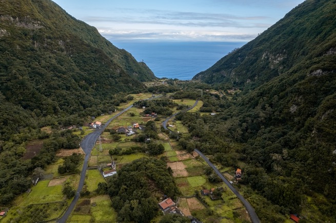
But, of course, as soon as I headed out, the rain stopped, and I saw a break in the clouds in the distance... I got back to the dirt road and followed it towards the coast. The dirt quickly turned into asphalt as the valley widened. I got my sights on the ocean and the small town of Seixal. By the time I had descended the last few hundred meters by stairs, it was sunny with blue skies.
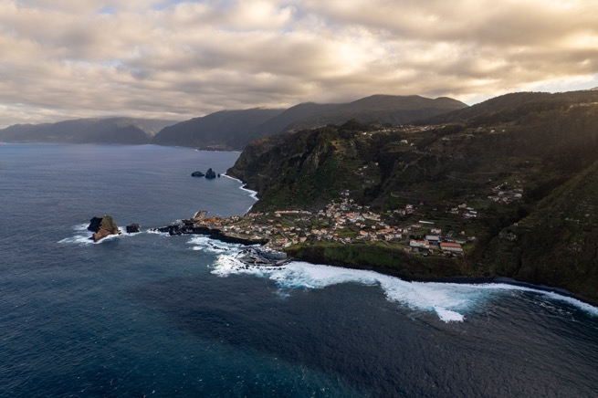
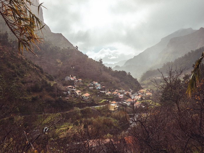
Seixal is a small, adorable village but can only be appreciated when seen from above. The town is built right on the edge of the cliffs, giving it a castle-like appearance shooting out of the ocean with the steep mountains right behind it.
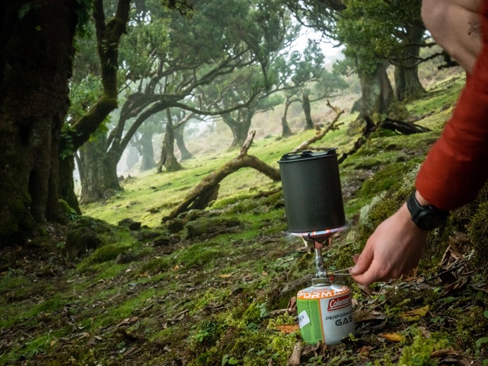
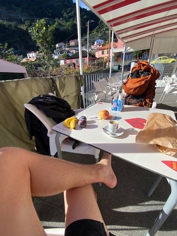
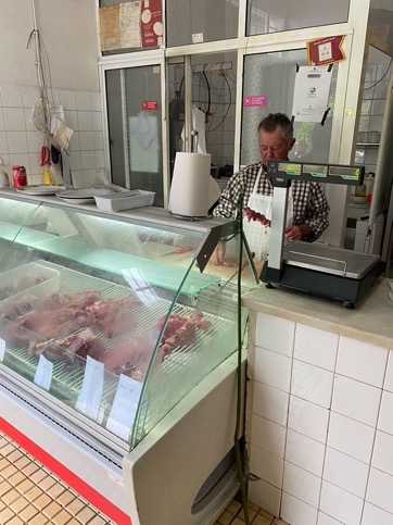
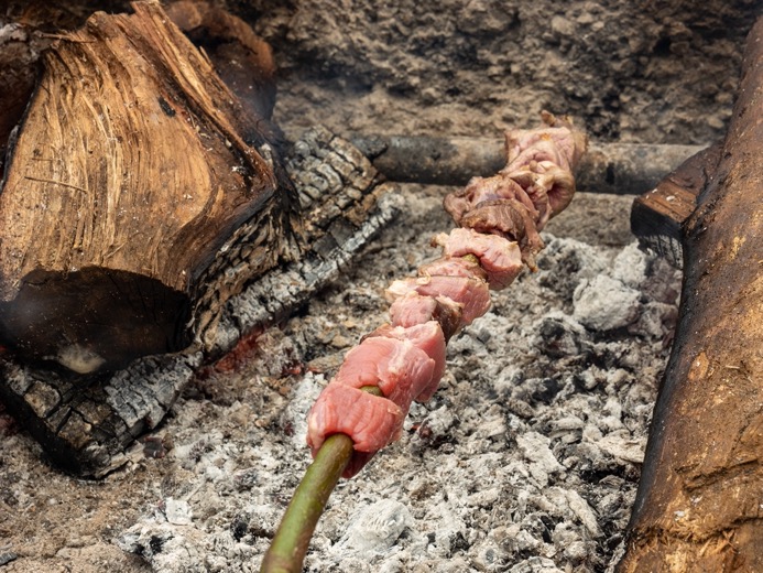
I took a long break at the local grocery store that also had a cafe. I dried my tent, clothing, and shoes in the sun while charging some of my batteries inside. After a resupply from the store, I had one last stop to make in town. The taxi driver that dropped me off in Porto Moniz the other day made a detour through Seixal to show me a local tradition: Espetada. A small and old butchery in town sells wooden sticks with beef seasoned with garlic and salt, uncooked. You then go outside and grill the meat yourself on a wood fire while overlooking the ocean. It's amazing, and without that tip from the taxi driver, I would have never stopped at this place.
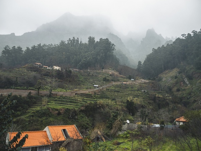
At 2 pm, with my pack and stomach full, I set out again for the next stage: a 1400m+ climb back onto the plateau. The clouds again had returned, and even though it was dry in Seixal, I could see the wet low clouds covering the mountain I was heading into. It being already so late, I put myself into machine mode and plowed my way up the mountain without a break. The climb was steep and basically all stairs in the forest, ideal for making progress. An hour later, I was already halfway when the first rain started falling again. Hidden under my poncho, I ground upwards until I reached the treeline a thousand meters up. It was particularly cold, but with the wind having free rein, I got wetter and colder as I continued up. I didn't really have a plan other than reaching the plateau and camping somewhere over there. With the hope the weather forecast from my Inreach was accurate this time (it has never been even close to accurate), I kept going on the plateau heading east. Close to getting really cold, I knew I had to find a campsite soon. On the map, I'd spotted a forested section with a picnic site 1.5 kilometers ahead. The vegetation so far on the plateau hadn't really been that interesting: just bushes and some smaller hills as far as the eye could see through the fog. But then suddenly, the forest appeared out of the fog, making me think it used to be a lot bigger in the past. Sheltered from the wind, I found a suitable campsite and in the pouring rain I pitched my tent outside in and got into some dry clothes.
I am definitely no fan of rain. I much rather have cold than the wetness that is almost impossible to dress for. Besides that, the rain kept me bound to my tent the entire evening. Luckily I had brought fresh bread from Seixal, which made dinner a slight moment of bliss.

\\ January 16 | Day 4: Rain on the plateau
Estanquinhos on the Paúl da Serra Plateau to hotel Estalagem da Encumeada via ER105
7.9km | 4.9mi
100m | 400ft 300m | 1000ft
Rain all night, rain all morning. At 11 am, it didn't seem like it was going to end anytime soon, so I put on my wet clothes, wet socks, and wet shoes, and packed everything wet while getting wet in the wetness of the rain.
I made my way down to the main road and started hiking east alongside it, trying to get a ride from anyone passing by. The route I had planned along a levada was out of the question for me. With only a rain poncho packed, I clearly wasn't ready for this type of weather. Before starting the hike, the weather forecast looked calm and with usually short rain showers. I hadn't packed for this amount of rain. Besides, filming in the rain is far from easy, keeping the gear as dry as possible, the lens free of condensation and drops, and the shots not looking like I'm in the most depressing place on the planet.
I finally ended up getting a ride from some Dutch people (who else) after 8 km, who happily drove me to the hotel a few kilometers further down the road. The hotel was actually really nice, with great views from the 2 balconies of my room. I dried my stuff and enjoyed the afternoon off.
\\ January 17 | Day 5: Pico Grande and a cave
Hotel Estalagem da Encumeada to Pico grande via trail PR1.3.
< 18.1km | 11.2mi
1500m | 5100ft 1000m | 3400ft
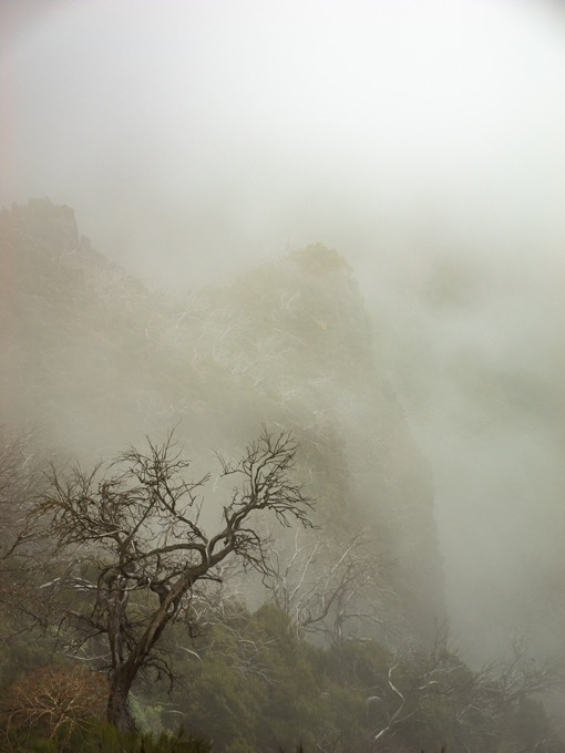
After a hearty breakfast, I set out for the rugged mountains of central Madeira. The weather looked better with some blue skies in the south, although the low clouds covering the mountains in the north worried me a bit. From the hotel, I headed straight up a mountain to join a levada heading north. I wasn't even 20 minutes in when the weather started changing for the worse as fog turned into light rain. A little annoyed by it, I sought shelter in the only small cafe/restaurant on the route for today. Instead of looking at the standard weather forecasts, I found the satellite imagery of the last few hours from which I could extrapolate that the clouds would break up in the afternoon. So I waited because the trail ahead of me was atop of a ridge, and with fog, there would be no point in heading up there.
Several coffees and two hours of waiting later, the satellite still followed my predictions, so I decided to give it a try. I ascended a steep trail, most of which was easy going on stone steps, until I reached the ridge line, which I followed east. There was still fog and little views, but it was a lot lighter than it was this morning, and every so often, I could see the shape of the sun through the fog, so my hopes were high.
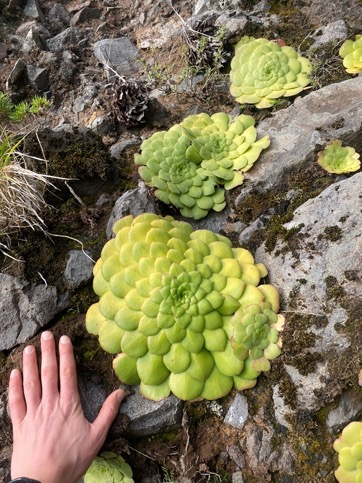
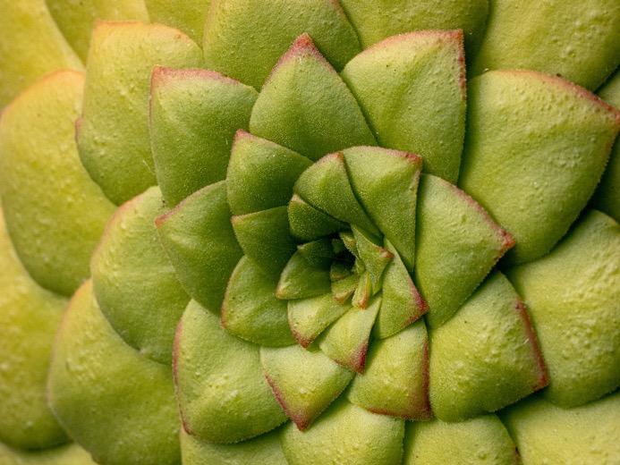
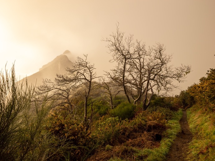
The trail passes through an area burned down by wildfires in 2010. Although the area is very green with all the green bushes and small trees, the massive white trunks still tower above it all, giving it a mysterious vibe in the fog.
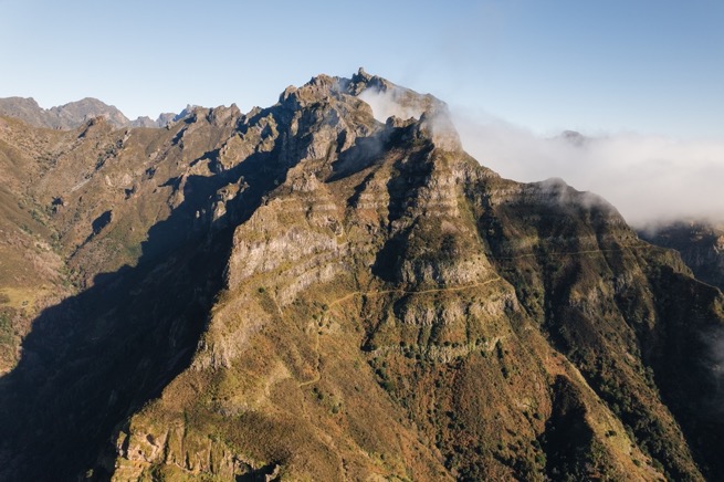
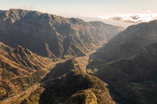
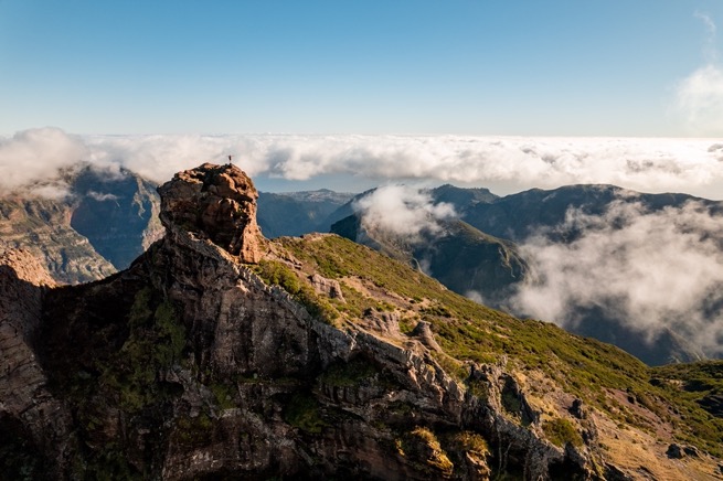
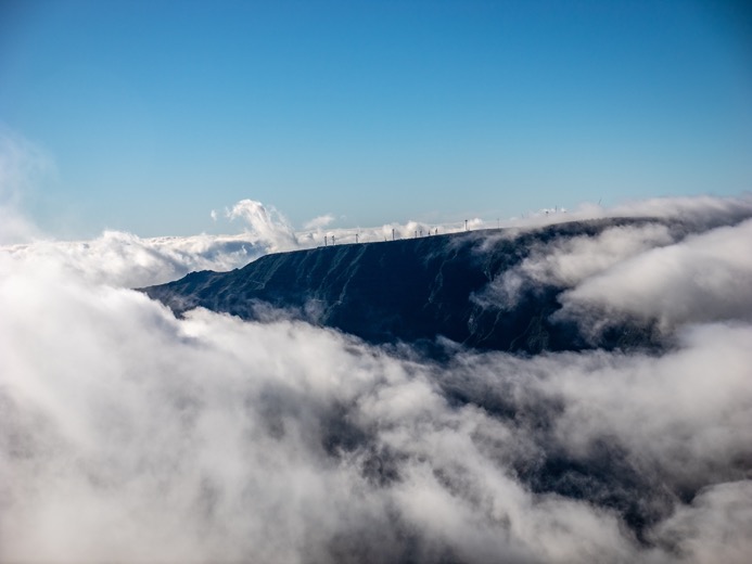
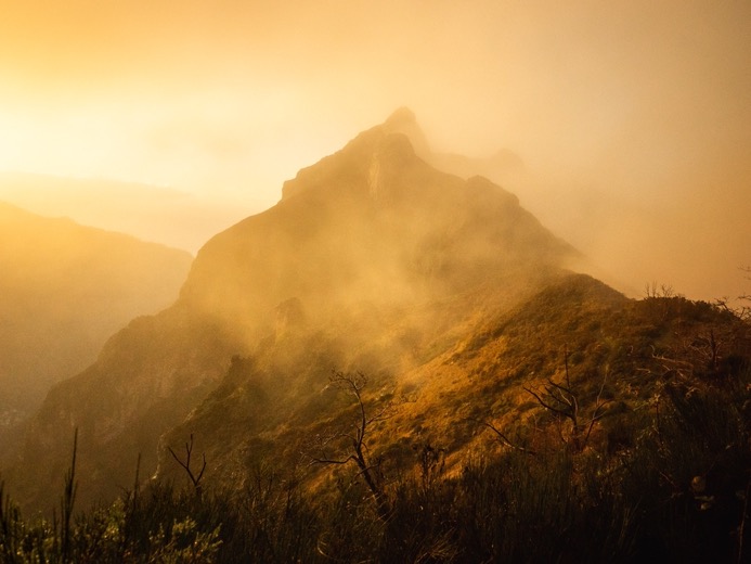
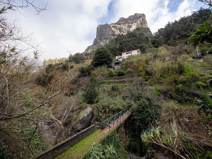
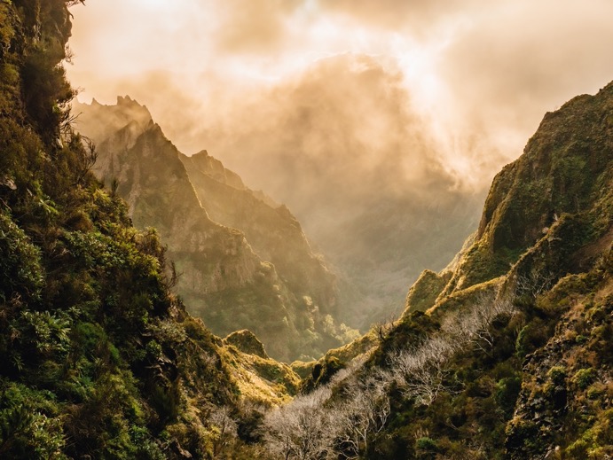
My plan for today was to reach Pico Grande, the second-tallest peak on the island. The great plateau of Paul da Serra, which I had just left behind, was mostly flat on top, with steep slopes diving down towards the ocean on all sides. This area is more rugged with a long ridge line going east to west and branching off to the south towards Pico Grande and Pico Arieiro. Enclosed between these ridges down the steep slopes is the deep valley of Curral das Freiras (Nuns valley). It's amazing how different the terrain looks and how much more open it is. I was just about to branch off the main ridge when the clouds really started to move out of the way. I sat down to enjoy the views with some snacks as I was flashed back to the Tour Du Mont Blanc where the fog similarly burned away as I had lunch, revealing the Mont Blanc itself.
The trail to Pico Grande is significantly more difficult than the easy-going trail upon the main ridge, but still easy going compared to many other places I've hiked. With a final 200-meter ascent, I was just below the stone rock formation that makes the peak of Pico Grande at 3 pm. The last part requires some scrambling up a rock wall with a rope permanently attached there. And there I finally got the views I was hoping for all day: looking down the 1,861 meters, I could see the ocean and Funchal as well as the remote village of Curral Das Freiras in the valley below. To the west, I could see the windmills on the Paul da Serra plateau peaking through the low clouds every now and then. To the north, I could see Pico Ruivo, the tallest peak of the island. Beyond that, I would have been able to see the ocean if it weren't for the clouds.
For the night, I had identified a campsite on Street View on a saddle about 300 meters below the summit. While there was some decent camping near the top, I wanted to descend part of the way and be lower on the mountain in case the weather turned bad again during the long day ahead. However, the campsite was not what I had hoped for, and I should have learned by now that picking campsites with Street View never works...
With the sun slowly setting, I walked up and down some trails but had no luck due to thick bushes everywhere. If I had stayed near the top, I would have had a better chance. Lesson learned.
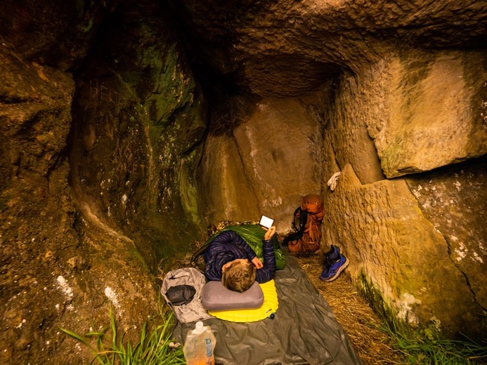
Out of options, I hiked back to a cave I had seen on my way down, not far from the saddle. After checking it for human waste, I found it to be a pretty decent campsite for the night. The floor wasn't big enough for my tent, at least not in a way that would allow me to get in and out easily, so I decided to cowboy camp in the cave. The cave was full of massive spider webs on the ceiling, which made me a little uncomfortable as I had always pitched my tent in caves in the past. However, I thought it was time for me to get comfortable with this situation. The more I can push myself to get comfortable in these kinds of situations, the easier it will be next time, and the more confident I will become on the mountain.
As I enjoyed the sunset changing the colors of the sky overlooking the Curral das Freiras valley, I had dinner and moved several spider families out of the cave (sorry, spiders). I laid down my ground sheet, mattress, and quilt, refreshed myself, and then crawled into my sleeping bag. I read a book as the fog outside turned into a very fine rain.
\\ January 18 | Day 6: Storm on the ridge
Cave underneath Pico Grande to the ridge near Pico Ruivo via Curral Das Freiras.
15.5km | 9.6mi
1300m | 4300ft 1100m | 3500ft
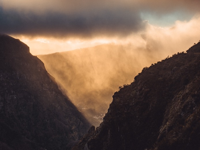
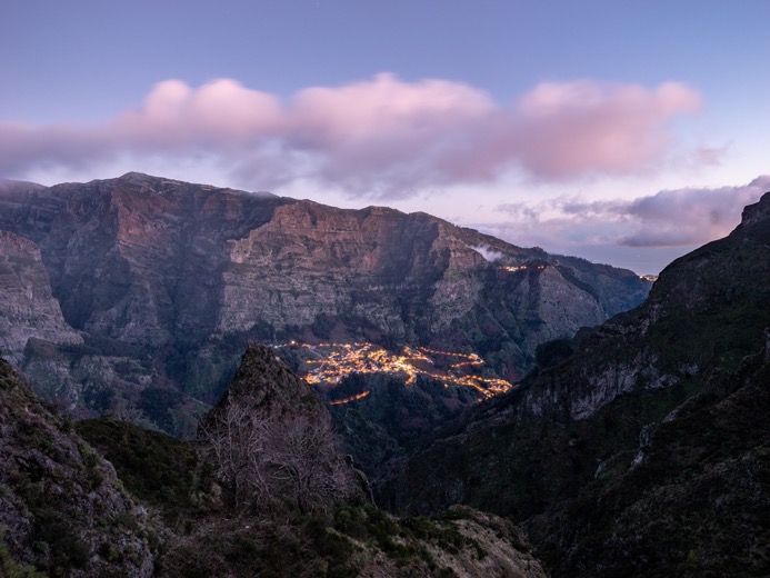
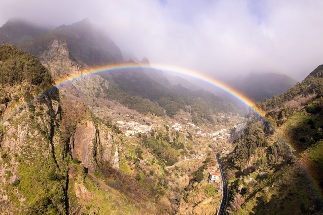
All in all, it was a pretty good night for a caveman. There were no angry spiders that kept me awake, and I stayed dry while everything outside was soaking wet. It was foggy outside, but the low, deep orange sun started to break through the clouds, illuminating the landscape with an orange blanket, which was perfect for cinematic looks. After breakfast, I packed everything up quickly and set out for the 700m descent to Corral Das Freiras in the valley below. I arrived in town just after 11am, when the sun had just peaked above the steep mountains around the village. The sky was blue in the south, but the ridge to the north, which I wanted to climb later on in the day, was covered in thick, grey clouds. However, I needed some time off; I felt pretty tired. I sat down on the south-facing terrace of a cafe with a coffee and some food, and tried to regain my strength. It was sunny, but there was a continuous, really fine rain resulting in a rainbow towards the north that lasted for hours.
At 1pm, I got some food for the next few days at the neighboring grocery store and set out. I hiked deeper into the valley towards the ridge. The village was quite spread out with houses and small farms everywhere, but it looked mostly abandoned. The deeper I got into the valley, the grayer the sky became, and it started to drizzle more. Still ahead of me was a 1100m climb towards the ridge. I put on my rain poncho and put in my earpods to let myself drift away as I climbed through dense Eucalyptus forests in the depressing drizzle.
The trail wasn't so steep and was easy going all the way up. As I climbed out of the forest on the south side, I got a first taste of what lay ahead on the ridge trail when the strong updrafting winds from the north hit me full on. But even then, I could see the beauty in the somber weather. Even though I didn't have the far views, the wind pushing the fog uphill through the trees certainly had a mystical look.
I headed east towards Pico Ruivo, a few kilometers down the ridge. The trail was flooded with creeks running on the trail. I was still warm from the climb, but being exposed to the elements up top, I started to cool down. Two kilometers in, I passed by an unofficial campsite that I had spotted on the maps, the only site I had seen so far along the trail. It was soggy but nicely sheltered from the wind by the bushes and away from the trail. I doubted whether to stay here or continue towards Pico Ruivo. The weather forecast for the next 24 hours was just like this, with "unseasonable cold and rain," so I didn't look forward to staying here and packing up wet again in the morning. But I also didn't know if there was any campsite ahead of me. It might take hours to find another suitable spot, and with me being wet and temperatures dropping towards zero, I finally made the wise decision to make camp and see it from there.
\\ January 19 | Day 7: Turning around
Rridgeline on PR1.3 (Vereda da Encumeada) near Pico Ruivo to Curral Das Freiras via PR2
8.9km | 5.5mi
200m | 700ft 1100m | 3600ft
The night was wet and, most surprisingly, cold. I certainly wasn't prepared for this kind of weather. All I brought was a rain poncho for the occasional rain shower, but I left my rain jacket and pants at home. With only one pair of long pants, I also didn't want to soak that pair, so I hiked in shorts, making the poncho look like a short dress.
I waited all morning for the weather to improve, regularly checking the satellite imagery with the spotty internet connection while reading a book, huddled up in my quilt with my clothes on. At noon, I decided I had waited long enough. The weather wasn't going to improve, and without proper clothing, there was no point in continuing along the ridge towards the tallest peak. Moreover, it would be another few hours of hiking to get to another town, and pitching a soaking wet tent in this weather wasn't something I was looking forward to doing.
So, I packed up my stuff and headed back down the same trail I had come up on yesterday, back towards Curral Das Freiras, and the leeward side of the mountain where the weather was somewhat decent.
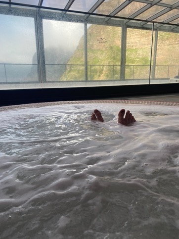
There are only two hotels in Curral Das Freiras. One was fully booked, and the other is on top of a ridge in the south, looking down on Curral Das Freiras, the valley, and north towards Funchal. I got a room here, dried my gear, and relaxed in the pool and Jacuzzi. The hotel is okay, but you definitely pay an absurd amount just for the views. For someone camping for free with even better views, it's not worth it. But it was nice having a proper bed and a warm shower. It was time for a new plan.

\\ January 20 | Day 8: The most beautiful trail on the island
Curral Das Freiras to PR1 via Pico Cerdo, Pico Areiro and Pico Ruivo
23.7km | 14.7mi
2200m | 7200ft 1600m | 5300ft
I was almost two days behind schedule. I had two options: skip the ridge and continue my island traverse east towards the coast, or do the ridge and then skip a section to get to the coast. Since the ridge with Pico Ruivo is one of the highlights of the entire route, I'd rather not skip the entire hike to the coast than skip this part. Besides, the part to the coast is getting less rough, more civilized and thus less interesting for me.
From the hotel, I could go down to Curral Das Freiras and then up the same route I came down on yesterday. But I discovered another route starting right at the hotel, climbing up a ridge that then passed by Pico Areiro. From here, I would walk north along a popular ridge trail (I would have originally walked north to south) to Pico Ruivo and see it from there.
The weather in the morning was chilly but calm, with even a little bit of sunshine. I walked along the road, then got onto a mapped trail climbing the ridge. It didn't take long for me to realize that this trail wasn't traveled often and definitely not an official route. I worked my way through thick vegetation, upon rocks and over dead trees, cutting myself multiple times on brambles. Half an hour in, and not even a fifth of my way to an actual trail, I turned around to find another route. It would be a long day, and I sure didn't feel like bushwhacking for 2 hours right at the start of the day.
I found another route up along a steep minor paved road. Not the most interesting hiking, but great progress. Half an hour later, I merged with the intended trail, and another half an hour later, I was on the ridge. I could see all the way down to the ocean at Funchal in the south. To the north, it was mostly clouded, still I could see some mountains in the distance. At 11 am, I was at the highest point of this ride, some 1000 meters up from the hotel: Pico Cerdo. It was sunny, but the wind had picked up and was blowing cold wet air up the ridge, freezing my hands, so no time to relax. Following the trail further east, the weather got gradually worse with fog and rain. I was close to Pico do Arieiro where I knew there was a restaurant to take shelter, so I didn't bother stopping to put on my poncho or rain cover for my pack. Completely soaked and cold, I walked into the restaurant at noon. And once more, I got into the repetition of waiting, drinking coffee, checking the satellite imagery, and listening to podcasts.
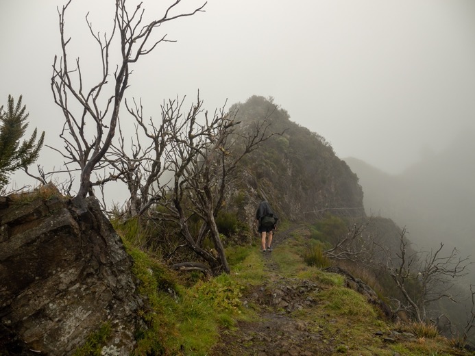
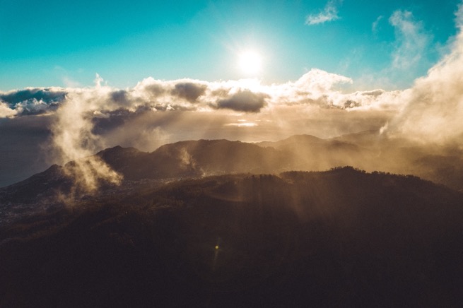
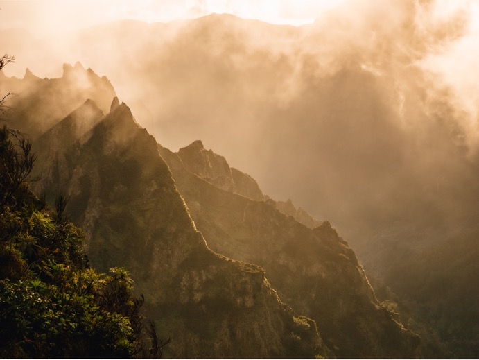
Two hours later, the fog seemed to slowly break up, so I continued with the most spectacular trail on the island: PR1 from Pico do Arieiro to Pico Ruivo. This trail is built right on top of the narrow ridge line. At some sections, it is only as wide as the trail with vertical drop-offs on both sides. The trail is mostly paved with stones with wire fences on both sides. As I started the 5-kilometer trek to Pico Ruivo, the fog started to move out, giving me some of the best views I've had so far. I quickly realized that this last 5 kilometers wasn't going to be fast: I just kept stopping to get more shots.
The trail climbs up and down and passes through several tunnels, some over a hundred meters long. The views are astonishing, especially looking down into the valley of Curral Das Freiras. Closer to Pico Ruivo, the trail moves to the west (leeward) side of the mountain, then climbs back over to follow the (foggy) east side. The climb to the tallest peak is not very difficult. Just below the summit, there's even a little bar that's only accessible by foot. At the top, I touched the peak marker, but couldn't see much due to the fog. Supposedly, you can see the ocean on both sides of the island from here, but I wasn't too disappointed. The weather on the most spectacular section up to this point turned out to be perfect.
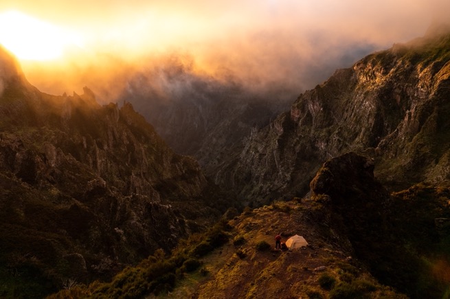
It was about 45 minutes before sunset, and I considered following the trail further east to camp somewhere along the way. I had spotted several small stone shelters with Google Streetview. However, on the east side of the mountain, it was foggy and windy. So instead, I decided to backtrack on the PR1 to the west side, where I had seen a campsite on my way there. I hurried to get there before sunset, basically running down, then climbing over the pass to find that this side was a lot sunnier. The little fog that was there was now beautifully illuminated by the sun low in the sky.
About 10 minutes before sunset, I arrived at the campsite, full of sweat and with tired legs after a 24 km day with a 2200m gain. With the sun just above the mountains in a fine fog, I quickly got my drone out to take some shots of me pitching the tent. I made it just in time! As I landed the drone, the sun was below the horizon, and the fog started to roll in from the slopes in the east.
The campsite, a bit down from the trail, offered a perfect view of the valley of Curral das Freiras. If it were clear, I should have been able to spot the approximate location of the campsite two nights earlier.
After one last trip to get some water from a little stream up the trail, I got into my tent to enjoy a proper meal with bread, cheese, and meat.


\\ January 21 | Day 9: Getting of the mountain
PR1 to Machico via Achada do Teixeira
6.8km | 4.3mi
300m | 1100ft 400m | 1400ft
I woke up to the sound of rain. Again. The fog had covered the entire valley. For one last time, I packed up everything in the rain, by now almost becoming good at it. I hiked back towards Pico Ruivo on the trail that carved out and through the rocks, looking amazing in a different way from yesterday's sunshine.
From the café just below Pico Ruivo, I headed east on PR1.1 until I got to the parking lot at Achada do Teixeira. I sat down in front of the fireplace to dry out my camera as I enjoyed a big cappuccino and brownie. Then, I managed to arrange a ride from a Dutch couple who dropped me off in Machico, on the coast just above Funchal, where I had planned to end my trek across the island. I had mixed feelings. I had been trekking for nine days, pushing myself pretty hard for several of them, and with the bad weather, I was happy to spend the night indoors. But at the same time, I felt disappointed for failing my plan to hike the full length of the island. However, I had seen so much beauty, and half of the time, the weather was okay, so I knew this feeling wouldn't last long.
\\ January 22 | Day 10: As far as one can walk east
Machico to Ponta de Sao Lourenco via Caniçal
23.7km | 14.7mi
1400m | 4500ft 1400m | 4500ft
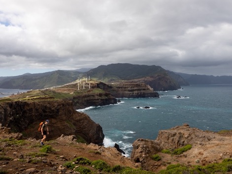
My last day on the island, and I certainly wasn't done hiking. I had planned to spend some extra days on the island to start editing, but as usual, I ended up hiking every single day. I still wanted to see the iconic eastern tip of the island, so after breakfast, I grabbed my (ultralight) backpack and set out.
From Machico, which, by the way, is one of my favorite towns on the island (small, not so touristy, old city center near the waterfront, full of old and massive sycamore trees), it's a hike along the ocean, over some hills, through the town of Caniçal, and onto the peninsula. It's about a 300-meter climb out of town towards the big hill next to the town, from which I got great views of the town with all its red roofs and the airport in the distance, with the runway partially elevated by large pillars.
The trail was nice, with great views of the ocean and the Islas Desertas in the distance. And most importantly, the weather close to the coast was great.
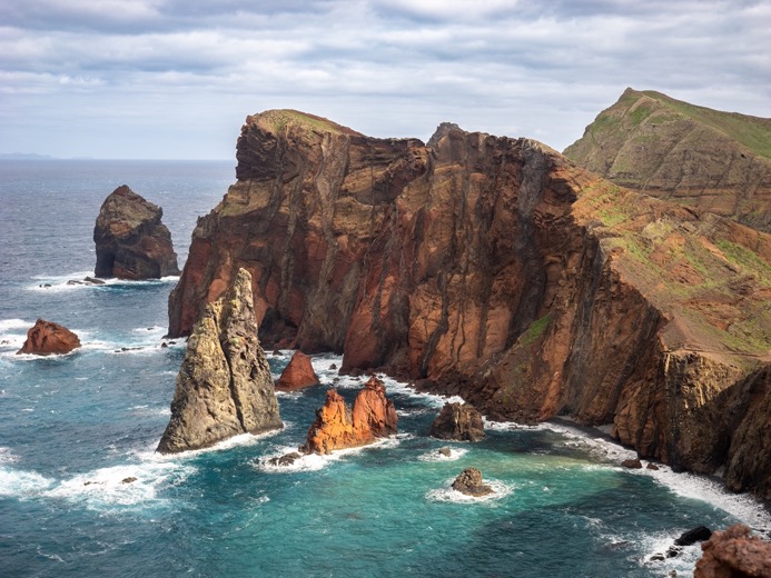
Based on Machico, I expected Caniçal to be nice too, but it turned out to be the exact opposite. There's a large harbor with massive fishermen's boats blocking the entire waterfront in the city center. Then, the footpath ends where some industries fenced off the entire waterfront, forcing me to walk on the road. I almost started to doubt my decision for hiking to the peninsula, but luckily, a few kilometers later, I found myself on some trails on the edge of the cliffs of the peninsula.
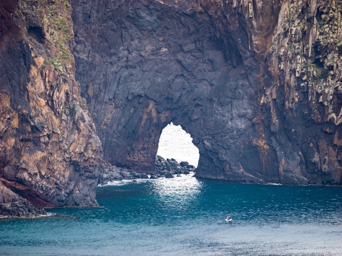
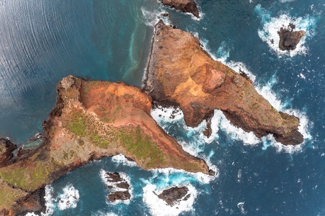
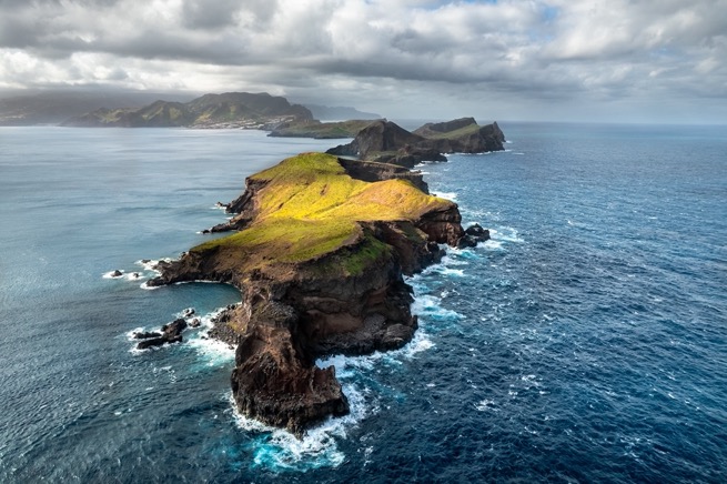
The peninsula itself is gorgeous. There is only a little village right at the start, and a small restaurant only accessible by foot or boat at the end. For the rest, it is empty. I followed the cliffs on the north side for a while on some semi-official trails. The views down to the water were amazing. The red rocks lit up beautifully in the sun and contrasted well against the cyan-blue water.
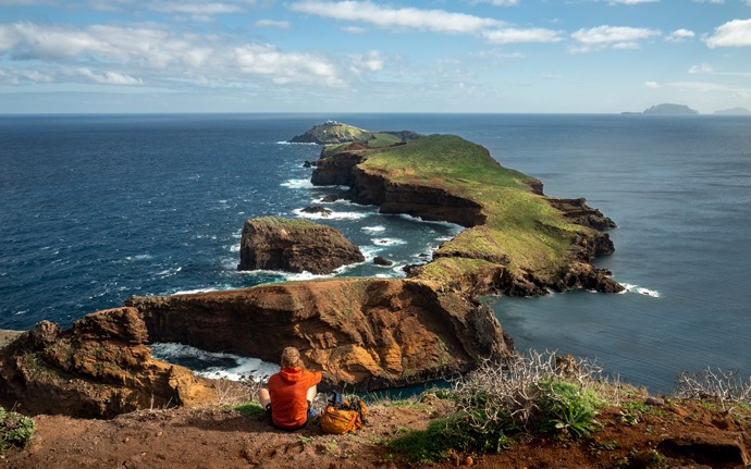
I merged with the main trail on the island, PR8. This trail winds over the cliffs and interior hills as the peninsula gets narrower and narrower. At the narrowest point, it's only 40 meters wide while being 50 meters tall. Several kilometers in, I climbed up the last mountain: Pico do Furado. And there the trail stopped. This is as far as one can walk east. Sitting on the top, I looked to the just-not connected islands further west with their green hills. I could see the lighthouse in the far distance. I flew out my drone for the last 3 kilometers to get some shots. Getting it back against the strong winds proved to be more difficult. I ended up diving the drone down to sea level on the leeward side of the islands to gain some speed before climbing up again to my launch spot.
I enjoyed the distant views from the top and reflected back on a great trip.