Backpacking Yosemite part 2/2
September 2019
Part 2 of my backpacking adventure in Yosemite National Park! Most of the trip details are in part 1. I took this second trip just a few days after the first one, and was eager to go.
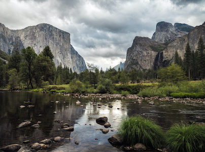
Part 2 in a summary: lots of climbing, cold nights, melting snow for water, enough food and best camping spot EVER. The route I planned took me around Tenaya Canyon and Half Dome. Starting in Yosemite Valley I climbed up to Clouds Rest, down to Tenaya Lake and back on the other side of the canyon to North Dome and Yosemite Falls.
\\ September 29 | Day 1: Waterfalls, climbing and snow
 Yosemite Valley Happy Isles to Clouds Rest via the Mist Trail
 15.4km | 9.6mi
 1628m | 5342ft  81m | 266ft
Oh yes! I was glad to leave the crowded Valley again. Well ‘crowded’; compared to a city it is inhabited, but after spending 5 days by myself during my first trip, it was crowded. This trip was a little less planned than the first one. I didn’t get my wilderness permit up to the day before, so had to do most of my packing on the morning I left.
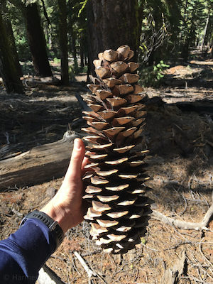
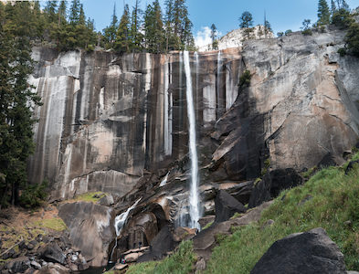
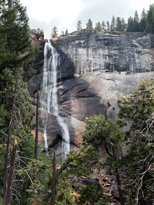
I left the Valley around noon. The first few miles were the toughest ones. I knew today was going to be at least climbing 5000 ft (1500 m) with a full pack, and with the 2-hour long run (at altitude) the day before I left tired. Also, after the hard lesson of not bringing enough food from last trip, my pack was heavier than ever. I hiked up the Mist Trail towards Vernal Falls and Nevada Falls. The trail gets its name from the mist of Vernal Falls in the summer; impossible to pass without getting soaked. But in the Fall, the waterfall is maybe a tenth of the size, and you barely get wet. Starting the hike I felt tired, but climbing the stairs next to Vernal Falls felt like a boost of energy. This trip was gonna be awesome!
OK, now something that really stands out to me every time I hike the Mist Trail. It’s the number of people you pass along the way. The first part to the bottom of Vernal Falls (the first real view point) you pass like 100 people per hour, the second part to the top of Vernal Falls it’s more like 50 per hour. Part 3 to the bottom of Nevada Falls it’s 25, to the top of Nevada Falls 12. You get the point, the number of people seems to decrease exponentially. And it doesn’t seem to be distance or elevation gain -related. It more seems like that defined viewpoints is where people decide: ‘I’ve seen enough, let go back down and eat’. The last 2 hours to my camping spot I passed 1 person. Day 2 I passed the first hiker 6 hours into the hike.
My plan was to camp somewhere just beyond Little Yosemite Valley, the valley above both falls. The next day I would hike over Clouds Rest, a giant granite mountain with great views at 9926 ft (3027 m). Looking at the map it seemed reasonably flat right beyond Little Yosemite Valley, so I thought finding a camping spot would be easy. Guess what: nope. I was climbing and climbing up to Clouds Rest, but all I found were sloped and overgrown steep hill sides not suitable for camping at all. It was getting late and colder. Temperatures had suddenly dropped over the weekend and the wind picked up. They even closed down roads in the park (Glacier Point Road and Tioga Road) because of snowfall.
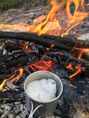
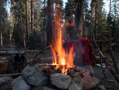
After hiking for another hour or so I decided to call it a day when I saw a somewhat suitable camping spot between the trees, just 600ft (200 m) below the summit. It wasn’t flat, but mostly out of the wind and with plenty of firewood around. I pitched my tent on the flattest spot against a big tree. Then it was time to solve my second problem: water. Being up higher than planned there weren’t any creeks and the creeks the last few miles were all dried up. Luckily some snow fell a day earlier and still some patches of inch-deep snow were left here and there. I probably would have survived with the water I still had left for a night, but feeling a light headache coming up, I was going to melt snow, on a campfire, in a small cup. It worked! Although I highly underestimated the effort. My cup only holds a few hands of snow, melting it takes forever, and the few sips of water you’re left with means you have to repeat it 10-20 times. Not to mention the bad smokey taste of the water or the sublimation of the snow if you’re not paying attention.
No water, melting snow, water tastes like smoke. Goes great with nothing.
The night was cold! My gear is rated for +5°C (45°F) weather. That night temperatures dropped well below -15°C (5°F) … I put on all the clothes I brought and wrapped myself in emergency blankets. Still cold. That night was uncomfortable, but for some reason I just accepted it, never regretted being up there. This was my decision, my adventure. Embracing the discomfort I got to sleep barely got any sleep and was happy glad to see twilight at 6am.
\\ September 30 | Day 2: Clouds Rest, Tenaya Lake and Snow Creek
Clouds Rest to Snow Creek via Tenaya Lake and Olmsted Point
21.9km | 13.6mi
711m | 2333ft 1114m | 3654ft
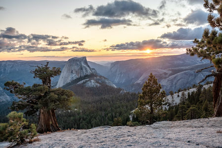
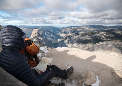
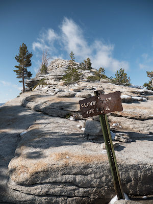
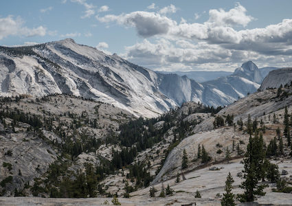
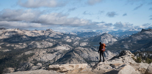
Speaking about beautiful mornings. I hiked the last mile up to Clouds Rest right after sunrise after a cold night. Hiking up a mountain with full gear is probably the best way to get warm. Contrary to hiking Half Dome, the views when hiking up Clouds Rest are still a surprise up to the very last moment as you hike up the tree covered side of the mountain. But wow, once up there I got goosebumps; not sure if it was the frosty cold and wind or the views, perhaps both. The views are 360 degrees around looking down into the Valley, on Half Dome and east towards Merced and Tenaya Lake. I would say one of the best views in the park. I enjoyed my dehydrated breakfast skillet sheltered from the wind as much as I could, while watching sun slowly breaking through the clouds. And the best part: no human being in sight.
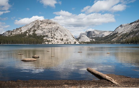
From Clouds Rest it was all pretty much down hill towards Tenaya Lake for 5.5 miles (9 km). The east side of the mountain clearly got a lot more snow, as the open forest was covered with a nice blanket of snow. With the sun out and shaded from the wind it was dead quiet, so peaceful. It reminded me of hiking in Lassen Volcanic National Park 2 years earlier. The park was mostly closed due to the thick pack of snow. Without any specialized snow gear, or essentially any (hiking) gear, I plowed my way through 50 cm (25 inches) of snow for 6 hours on a completely windless and cloudless day. Now, 2 years later I was a little bit more prepared.
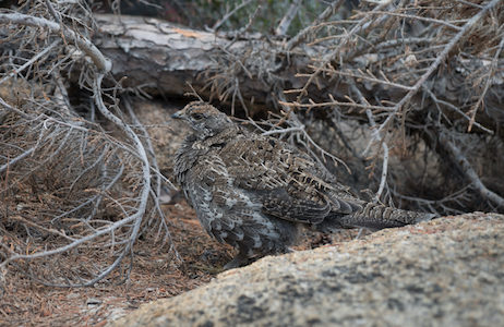
At Tenaya Lake I enjoyed lunch accompanied by camouflage-bird. I also saw people for the first time in 24 hours. These trails are definitely more popular than the trails of the first trip I took a few days earlier as these come close to Tioga Road, the one road crossing the park. But nevertheless, 30 minutes away from the road and all solitude is back.
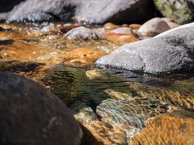
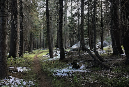
From Lake Tenaya I walked below Olmsted Point to Snow Creek Trail. The first part of this trail really surprised me. Yosemite as I know it is mostly open forest, with slabs of granite everywhere. This first part did not look anything like that. It was a wet densely forested valley with grass and greens everywhere. This dark forest did not feel like Yosemite anymore, an alternation I really enjoyed.
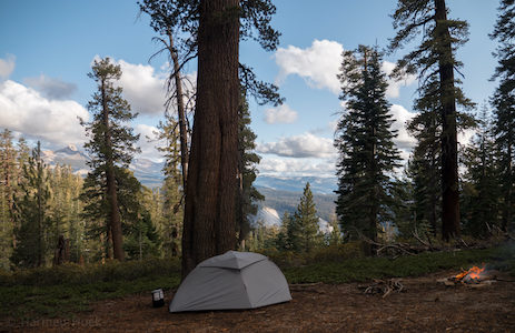
I camped almost 5.5 miles (8.9 km) from Lake Tenaya. Finding a good campsite was harder than I expected: there weren’t that many dry, open and flat sites. But I found a nice spot in a forest, close to but hidden from the trail. The night was as peaceful as it can get for me with a fire, warm meal, clear skies in a quiet pine forest with the sounds of a small creek in the distance.
\\ October 1 | Day 3: Indian Canyon
 Snow Creek to Indian Canyon via Indian Rock and North Dome
 15.0km | 9.3mi
 705m | 2313ft  744m | 2441ft
The second night wasn’t as cold as the first one, but still cold enough to freeze up everything. In the morning I had to use a fire to thaw the water filter and tent poles. Drinking water from my bladder resulted in a frozen tube within 5 minutes. And the worst part was filtering water from the creek. The filter, which already has a minimal throughput, constantly froze reducing the throughput even more. And wet hands for 15 minutes around freezing is no fun either.
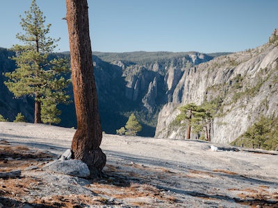
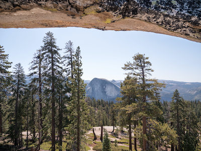
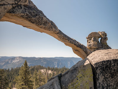
I packed up my gear after my failed attempt of baking pancakes on a stone above the fire and left around 9:30. I headed further west to Indian Rock and bushwhacked my way through some dense forest to cut the trail a few miles. Indian Rock is a natural stone arch on the top of a hill with great views of Half Dome. Atop of the rock I enjoyed a good coffee, beef jerky and a book. Sun was out and no wind at all.
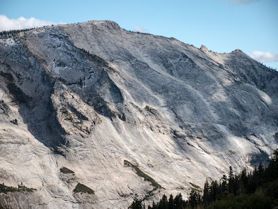
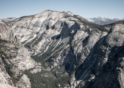
The hike wasn’t particularly long or hard today, so I added an outing to North Dome. As the name suggests North Dome is a granite dome on the north side of the Valley overlooking the Valley and Half Dome. I think I can best describe the route for this trip as the all-possible-view-of-Half-Dome-route. You literally hike around Half Dome, seeing all possible angles of that rock.
Oh yea, the bear! Close to Indian Canyon I saw a small black bear cub at least 15m (50ft) up in a tree. With its belly on a branch and its four legs dangling it seemed to enjoy a nap in the sun. But where there’s a cub, the mum usually isn’t far away. Didn’t see her however, but hiked carefully for a while.
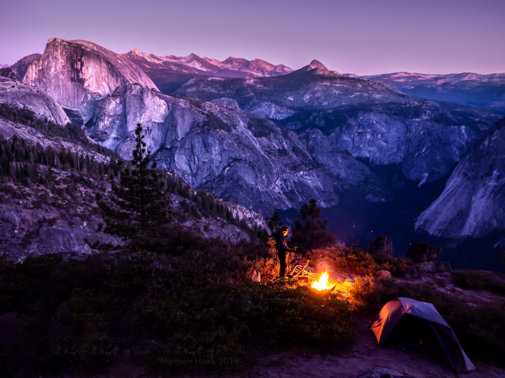
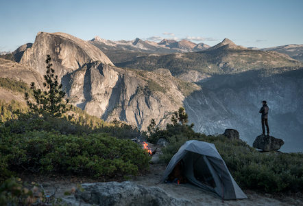
For my last night I had one particular camping spot in mind, the spot that inspired my to go backpacking in Yosemite in the first place. Last March I met John , an outdoor enthusiast and writer when spending a night in Yosemite Valley. He showed me the location of this one spot high above the valley with this amazing backdrop of Half Dome. Using his approximate location and picture I set out to find this exact spot and I did! And wow, what a camping spot it was. Right on the cliff looking down into the Valley and Indian Canyon and overlooking the Clark Range and Half Dome. Perhaps the most beautiful spot I ever camped. I think the pictures below speak for themselves. And the fun fact is that’s it is free and you have the place to yourself.
Spend the last night at the campfire reading the last chapters of ‘Into the Wild’, an appropriate book for this trip I thought. Sunset was amazing, and in the dark I could see the lights of climbers on the face of Half Dome.
The heavens declare the glory of God; the skies proclaim the work of his hands.

\\ October 2 | Day 4: Yosemite water-less-Falls
 Indian Canyon to Yosemite Valley via Yosemite Falls Trail
 11.5km | 7.1mi
 178m | 583ft  1030m | 3380ft
Mornings are the best. Period. How I enjoyed the views with some breakfast on the cliffs. A great way to end the trip. The trail back to the valley took me atop of (water-less) Yosemite Falls. These were some of the first trails I hiked in Yosemite 2 years ago when Yosemite was still one big mystery ready to be explored. I would not have guessed than that I would be doing trips like these in the park I feel like I know pretty well by now.
What a grand two weeks in Yosemite these were. I lived in the moment the entire time I was here, not worrying or even thinking about things I have to do back home. I pushed my boundaries again, making myself feel comfortable in extremer conditions. It is at this fine line between comfortable and uncomfortable where I really value life, where I feel alive. At my limits, pushing my limits. What I take home from these two trips is the freedom of minimalism and the natural rhythm. I’m not the first one drawing this conclusion, so it might sound cliché, but the minimalism of a trip like this really taught me that you you don’t need much to be perfectly happy and comfortable. It does change my perspective in life in general. It’s a special feeling having everything you need to survive on your back. And secondly the natural rhythm feels so … natural. Waking up at sunrise at 6am and going to bed at 8-9pm makes me feel more productive and energetic. With our modern luxury this is so hard to do, as we tend to be awake for longer. Looking forward to my next adventure.
It is at this fine line between comfortable and uncomfortable where I really value life, where I feel alive.